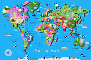
Illustrated Kids World Map
Illustrated Kids World Map
Illustrated Kids World Map - by children's artist Carla Daly.
Exciting news this week as I am signing with a new art licensing agent in the United States. Out Of The Blue art licensing will be representing my work for the next few years. I am very excited about it as art licensing is an area I am eager to get into.

I have spent the week scanning in all my artwork and sending it to them. I am also busy creating new images, like this Illustrated Kids World Map. I am using less colour,
Less detail and more pastel colours, I know unusual for me! I want a different take on my artwork and want to open as many doors as possible for my work.
You can browse more of my illustrated kids maps online at Gifts4Baby.ie, I have another very popular illustrated kids world map for sale, see image below.
Two quite different maps but both great fun for kids. The above image includes as many countries of the world I could fit in, with icons representing a country or city. This map is a large print measuring 50 x 70cm and printed on a high quality photographic paper. At Gifts4Baby.ie we offer free shipping on all our illustrated kids wall maps (within Ireland).


Comments
Post a Comment